


 |
MTSAT Colourized Infrared
Satellite Image
8:33pm Thu 19 Feb 2015
|
Check out our latest post for the most up-to-date info!
Severe Tropical Cyclone Marcia lies over the Coral Sea approximately 160km east northeast of Mackay. The cyclone is expected to turn more southwest during the next few hours and make landfall between Mackay and Gladstone early on Friday as a Category 5 cyclone. A trough extends southwards from the tropical cyclone near the Wide Bay and southeast Queensland coasts.
 |
| Forecast Track Map as at 8:04pm |
Whilst TC Marcia doesn't pose a direct threat to the Gold Coast, the swell she is generating along with bringing a trough into the southeast of the State, a Severe Weather Warning remains in effect for damaging winds, heavy rainfall, abnormally high tides and dangerous surf, along with a Flood Watch for riverine flooding (a copy of warnings at bottom of this post).
 |
| Resident line up for sandbags at Southport SES earlier today |
Mayor Tom Tate urged the Gold Coast not to panic, as concerned residents lined-up for sand bags provided by the State Emergency Service at Southport.
“What I say to you is about midnight tonight is really when most of the potential major rain will occur and 10pm the next day."
HEAVY RAINFALL
When will it rain? Check the latest 3-hourly detailed forecast.Widespread rainfall totals of 200-400mm are still forecast, with some 24 hour totals possibly in excess of 300mm. The heaviest rainfall is expected to fall within coastal catchments. The heaviest rainfall is expected to fall within coastal catchments.
.png) |
| Forecast Rainfall for 20-22 Feb 2015 |
RIVERINE FLOODING
Heavy rainfall associated with the trough is forecast to affect catchments between Rockhampton and the NSW border from tonight through to Saturday.River level rises above the minor flood level are expected. Catchments at risk within the Flood Watch area include the Albert and Gold Coast rivers and creeks.
A Flood Watch means that people living or working along rivers and creeks should monitor the latest weather forecasts and warnings and be ready to move to higher ground should flooding develop.
Heavy rainfall may also lead to localised flash flooding.
DAMAGING WINDS
Damaging winds gusts of up to 90 km/hr are possible starting tonight into Friday (mostly near the coast and ranges) with sustained winds of 30 to 45 km/hr.
ABNORMALLY HIGH TIDES
This morning a 2.17m king tide scarped beaches at Kirra, and more 2m king tides are expected Friday.
LOCAL DISASTER MANAGEMENT
City of Gold Coast Local Disaster Management Centre is now up and running to monitor the event. For further information, you can contact the Disaster Hotline on 1800 606 000.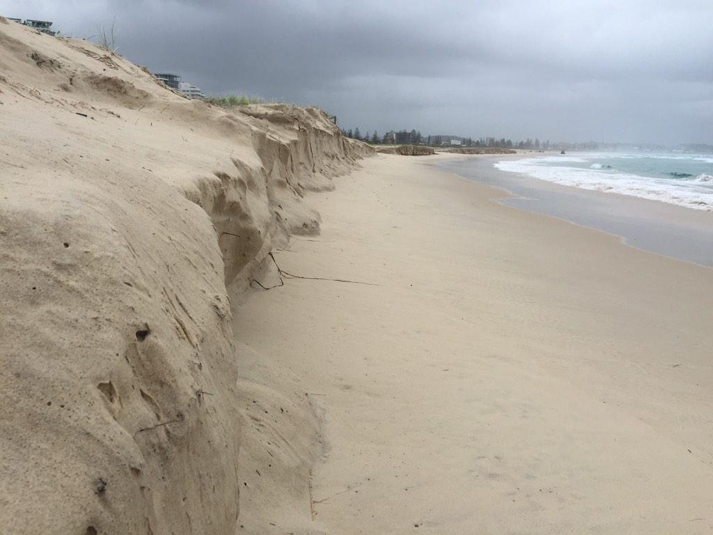
BE PREPARED, NOT SCARED
If you do need assistance, here are some essential contact numbers- For any life threatening emergencies, call Triple Zero (000)
- For assistance with flooding or storm emergencies, call the State Emergency Service (SES) on 132 500
- For emergencies such as powerlines down, call Energex on 13 19 62
- For loss of power supply, call Energex on 13 62 62
- For issues with your water or sewerage service, call City of Gold Coast on 1300 000 928
- For issues with local roads, stormwater or parks, call City of Gold Coast on 1300 465 326
- For road closure information, call 13 19 40
SEVERE WEATHER WARNING
for DESTRUCTIVE WINDS, HEAVY RAINFALL, ABNORMALLY HIGH TIDES and DANGEROUS SURFFor people in the
Southeast Coast and parts of the
Wide Bay and Burnett and
Darling Downs and Granite Belt Forecast Districts.
Issued at 6:00 pm Thursday, 19 February 2015.
Synoptic Situation:
Severe Tropical Cyclone Marcia lies over the Coral Sea approximately 160km east northeast of Mackay. The cyclone is expected to turn more southwest during the next few hours and make landfall between Mackay and Gladstone early on Friday as a category 4 cyclone. A trough extends southwards from the tropical cyclone near the Wide Bay and southeast Queensland coasts.
Heavy rain and locally damaging wind gusts are possible from the coast to the ranges between Double Island Point and Brisbane, extending to the state's southern border and the eastern Darling Downs and southern Burnett later tonight and Friday. The heavy rain may lead to flash flooding, with some 24 hour totals possibly in excess of 300mm. Damaging wind gusts may reach around 90 km/hr, mostly near the coast and ranges.
Water levels on the high tide are likely to exceed the highest tide of the year from today. Dangerous surf conditions and beach erosion are also expected on exposed beaches.
Riverine flooding:
A flood watch is current for the Wide Bay and Burnett, Southeast Coast and the Darling Downs & Granite Belt District forecast districts.
A Tropical Cyclone Warning is current for areas between Bowen and Double Island Point.Tropical Cyclone Watch is current for adjacent inland areas between Bundaberg and Double Island Point.
Locations which may be affected include Warwick, Gold Coast, Toowoomba, the Lockyer Valley, Ipswich, Brisbane, Caboolture, the Sunshine Coast, Kingaroy and Gympie.
Queensland Fire and Emergency Services advises that people should:
* Move your car under cover or away from trees.
* Secure loose outdoor items.
* Seek shelter, preferably indoors and never under trees.
* Beware of fallen trees and powerlines.
* Avoid driving, walking or riding through flood waters.
* Keep clear of creeks and storm drains.
* Surf Life Saving Australia recommends that you stay out of the water and stay well away from surf-exposed areas.
* Check your property regularly for erosion or inundation by sea water, and if necessary raise goods and electrical items.
* For emergency assistance contact the SES on 132 500.
The next warning is due to be issued by 12:00 am Friday.
Warnings are also available through TV and Radio broadcasts, the Bureau's website at www.bom.gov.au or call 1300 659 219. The Bureau and Queensland Fire and Emergency Services would appreciate warnings being broadcast regularly.
FLOOD WATCH
FOR THE CAPRICORNIA, WIDE BAY & BURNETT, SOUTHEAST COAST AND DARLING DOWNS & GRANITE BELT FORECAST DISTRICTS
Issued at 11:46 am EST on Thursday 19 February 2015
Issue Number: 3
Heavy rainfall associated with a trough is forecast to affect catchments between Rockhampton and the NSW border from Thursday through to Saturday.
Widespread rainfall totals of 200-400 mm are forecast, with locally higher rainfall likely. The heaviest rainfall is expected to fall within coastal catchments. A severe weather warning and tropical cyclone advice are current for parts of the Flood Watch area.
River level rises above the minor flood level are expected.
Heavy rainfall may also lead to localised flash flooding.
Catchments at risk within the Flood Watch area include the Dawson, Calliope, Boyne, Baffle, Kolan, Burnett, Cherwell-Burrum, Mary, Noosa, Maroochy, Mooloolah, Brisbane, Logan, Albert, Gold Coast rivers and creeks, Upper Condamine, Border Rivers and Moonie.
See www.bom.gov.au/qld/warnings/ to view the current flood warnings for Queensland.
This Flood Watch means that people living or working along rivers and creeks should monitor the latest weather forecasts and warnings and be ready to move to higher ground should flooding develop.
See www.bom.gov.au/qld/flood/brochures/flood_watch/ for further information about Flood Watch.
Remember: If it's flooded, forget it.
For flood emergency assistance contact the SES on 132 500.
For life threatening emergencies, call Triple Zero (000) immediately.
Current emergency information is available at www.disaster.qld.gov.au .