November 7, 2010

Windy, wet and wierd

What was expected to be a fine Saturday night / Sunday morning with showers 'cheifly inland', appears to have changed it's mind.

After some relatively windy conditions and showers, the weather radar at around 2am shows a distinct clockwise 'swirling' motion, with a rain band on the southern side/approach.

This image is not to dissimilar to previous 'east coast lows' and other low pressure systems that bring a bit of rain (sometimes moderate to heavy falls).

Now call me eager, but I think there's going to be than just 'fine' conditions coming up on Sunday morning.

Otherwise, as most people are sleeping or never actually read these posts, it probably doesn't matter anyway! Leave a comment to prove me wrong - are you reading this at 2am?

October 10, 2010

Batten down the hatches

Damaging 90km/h wind gusts and flash flooding is possible for people in the Southeast Coast district after the Bureau updated it's Severe Weather Warning at 11:05 am on Sunday 10 October 2010:

The combination of an intensifying high over the Tasman Sea and a deep trough off the southern Queensland coast is expected to produce wind gusts in excess of 90 km/hr, mainly along the exposed coast and over the islands.

As the trough moves closer to the coast expect increasing rain during the day with locally heavy falls developing from the south, particularly late in the day or overnight, with the possibility of flash flooding.

The State Emergency Service advises that people in the affected area should:
· seek shelter, preferably indoors and never under trees
· secure loose outdoor items
· beware of fallen trees and powerlines
· avoid driving, walking or riding through flood waters
(Source: BOM)

Additionally, Emergency Management Queensland issued a Severe Weather Advice today:

Emergency Management Queensland is urging all residents along the southern Queensland coast to prepare for heavy rain and strong wind gusts later today and tonight.

The Bureau of Meteorology has advised that strong wind gusts will occur in coastal areas with increasing rain throughout the day and heavy falls developing in the afternoon or tonight, with the possibility of flash flooding.

State Emergency Service (SES) volunteers are on standby but residents are being reminded to prepare their homes to best avoid damage to property.

People are being urged to listen to local radio, secure loose items, clear their gutters and to seek shelter indoors and not under trees.

A flood warning remains current for Sunshine Coast streams and Hinterland areas and people in those areas are reminded to avoid walking, driving or riding through flood waters.

Overnight the SES reported a quiet night with the latest information indicating that in the 24 hours to 5am today, volunteers in the Brisbane region attended 23 jobs, in the North Coast Region they completed 10 jobs and in the South East Region there were seven jobs.

Almost all of these jobs occurred yesterday and were of a minor nature.

For storm and flood assistance contact the State Emergency Service on 132 500 and in a life-threatening emergency call triple zero (000).


October 8, 2010

Spring has sprung...a leak!


Between 40-80mm of rain has fallen since 9am around the Gold Coast, with the heaviest falls around Robina (56mm to 11pm at Boobegan Creek) and Springbrook (83mm to 11pm).

The archived 256km Radar Loop for Brisbane
(provided by theweatherchaser.com) shows a line of rain/storms whilst relatively isolated to the coastal strip made it's way north from about Southport at midnight with heavy falls continuing until it disapated north of Maroochydore around 6am.

The morning on the coast was relatively dry until more moderate to heavy falls moving north-west made landfall around 10-11am in the centre of the coast, with a further band of showers heading south-east.

As the radar loop shows, as these two fronts combined, further rain started developing to the north of the Gold Coast in an almost 'circular' pattern (similar to a swirling low or cyclone). Currently the heaviest falls are to the north of Brisbane, with a Flood Warning issued by the Bureau at 11:06pm for Sunshine Coast streams and rivers.

As far as my personal opinion goes along with years of experiencing weather patterns in south-east Queensland, getting this much rain in Spring is really out of the ordinary. Normally from about September onwards, the only real 'rainfall' that we experience is from thunderstorms or lighter coastal showers.

However, it appears that this year, the weather pattern has changed with seemingly continuous showers and rainfall that doesn't seem familar to me. Maybe it's just that I've live most of my life in a drought situation in Queensland and never saw (or had the tools to see) how weather patterns existing pre 1990.

From what I can see, the rainfall we are experiencing at the moment almost represents an East Coast Low situation that whilst they can occur at any time of the year, they are more prominent in autumn and winter. Additionally, the radar images show a 'circular' pattern which also appears to be related to a low pressure system, but normally the heavier rain falls occur on the southern side of the low. Tonight's weather pattern shows the heavier falls to the north.

In my mind, I can only assume that these weather patterns is because of La Niña climate phase. According to a BOM media release in June:

Historically, La Niña events have often, but not always, brought above average rainfall to much of Australia, particularly inland eastern and northern regions. Night time temperatures are also usually warmer than average. Tropical Cyclone risk for northern Australia also increases during La Niña events.

Widespread wet conditions and flooding events have accompanied a number of La Niña events in the past. Substantial flooding impacted NSW and Queensland in the event of 1998, while the event of 1988-89 saw flooding also occur in SA and Victoria.

In general, while La Niña events tend to be wetter than normal for Australia, no two La Niñas have exactly the same impact on local rainfall. So while some regions may experience the typical pattern of heavy rainfall, other regions may miss out altogether.

Actually, I do remember the flooding in 1998 - from memory there were actually two flooding events no more than about 1-2 weeks apart (this is when I was living on the Sunshine Coast). The second event started around 8:30 at night - as we were trying to watch 'Ally McBeal' on TV and because we had a tin roof, the rainfall got so heavy the TV wouldn't go any louder.

Throughout the night it just kept raining and raining, our backyard was under water, the street was under and the water came halfway up our driveway. We were lucky as our house was slightly higher than the other end of the street. Some of our distant neighbours had water lapping at their doors, with one house having raw sewerage coming out of the drains in the floors of the bathrooms because it had no where else to go.

Anyway, I'm interested to know for those of you who've lived here longer than I have, describe what your opinion of the weather patterns have been over the past month?

August 7, 2010

Rain on the frosty horizon

Significant rain areas on Tuesday afternoon/evening are forecast to develop with moderate to fresh and gusty N to NE winds ahead of SW change.

The current extended forecast from the Bureau of Meteorology predicts an upper trough should cause significant rain areas to develop over the central and eastern parts of the state . The rain should start inland at first, and then move eastwards to reach the coastal districts later in the day. Moderate to fresh and gusty N to NE winds over eastern districts ahead of a SW change moving eastwards across the state.

Additionally, the computer generated Rainfall Forecast maps also predict significant falls for most of the state, with the south-east corner expecting 25-50mm on Tuesday alone, with the possibility of up 50-100mm on Wednesday for the Gold Coast.


The extended forecast for Wednesday will see the upper trough will move east across the state, with the cloud and rain band over eastern districts clearing during the morning. In the wake of the cloud and rain band, cooler and drier S to SW winds should again spread across the state due to a new high pressure system moving eastwards across the Great Australian Bight. As always, these are only forecasts and the situation may change.

However until then, the south-east corner gets to shiver over another cold night, with inland areas going down to -2 degrees at Ipswich, but staying warmer near the coasts with minimum temps of 9 degrees for the Gold Coast warming to a beautiful fine day with an expected top of 23.

July 28, 2010

July 19, 2010

June 3, 2010

Chance of drizzle starts to fizzle

The expected moderate falls of up to 25mm this morning on the Gold Coast has fizzled out, with forecasts for the remainder of today predicting only possible showers and local thunder.

Rainfall Forecast maps now only show the possibily of falls between 5-10mm today around the Gold Coast.

However, the NSW central and mid-north coasts are still likely to receive the heaviest falls right through until Monday as an east coast low continues to develop off the coast, and is currently positioned near Byron Bay.

A Severe Weather Warning for the north-eastern parts of NSW has been issued for possible flash flooding and thunderstorms.

However, the low is expected to head south from Friday, and here in the coast the weekend outlook for the Gold Coast is mostly fine, with just a few showers.

June 1, 2010

Unsettled conditions from Thursday

Widespread showers and thunderstorms tending to rain at times during morning is expected on Thursday, with some moderate falls of up to 25mm predicted for the Gold Coast.

This weather comes after the south-coast of New South Wales continues the clean up after wild weather struck the region over the weekend, with eastern and mid-north NSW regions preparing for more wet weather and possible gale force winds between 40-70km/h. (Source: Weatherzone)

May 31, 2010

Cool nights plus cool gadgets

It was another fresh night and morning with temps dropping to 8.6°C degrees at Coolangatta (at 12:00AM midnight), with the Gold Coast Seaway slightly warmer at 12.7°C degrees (at 6:30am).

May 20, 2010

Light rain & thunder to end the week

Up to 15-25mm of rain may fall around the Gold Coast in the morning tomorrow, Friday 21st May 2010, then tending towards showers in the afternoon/evening with possible thunder.

May 14, 2010

Coldest morning so far for 2010

Temperatures dropped to 10 degrees Celsius on the Gold Coast overnight at Coolangatta, and 12.5 degrees at the Gold Coast Seaway, breaking the lowest 'official' temperature record for this year (so far!).

The coldest temperature ever recorded for May was 1.5 degrees at Coolangatta in 2000, and 6.5 degrees at the Gold Coast Seaway in 2004 (Source: Weatherzone). Residents further west towards the Hinterland are likely to have already experienced lower temperatures.

Daytime temperatures are set to be 24 degrees over the next three days, with a fine forecast for today (Friday) and mostly sunny over the weekend. Looking further into next week and rain is forecast to develop on Monday.

May 9, 2010

Evacuation centre locations revealed

The location of the Gold Coast's 96 evacuation centres has been made public by the Gold Coast Bulletin after Gold Coast City Council received $110,000 from the State and Federal governments' Natural Disaster Resilience Program this week.

The news article published on 8th May, quoted Local Disaster Management Group (LDMG) deputy chairman Ted Shepherd :

"... the council would now extend its emergency plan and print booklets, which would include evacuation points."

"We had a generic evacuation plan done for the LDMG ... for in-house disaster management," said Cr Shepherd.

"This will allow us to extend that with more definitive details and we can put it in a nice document and get it out to residents." (Source: Gold coast Bulletin)

The article also states Councillor Dawn Chrichlow saying the full list of centres "should have revealed the centres as soon as they were planned" and that apparently the Councillors were not aware of the centres until they were request by the Gold Coast Bulletin.

The council had previously refused to disclose the 96 planned safe havens, (and) at the time, Mayor Ron Clarke said letting people know where to flee before a bushfire, tsunami or flood would be an information overload that may lead to residents flocking to the danger zone. (Source: Gold Coast Bulletin)

The list, which would have likely already been available to the Council's disaster management unit as lists of potential venues that could be used as evacuation centres, but their suitability and safety would be determined by experts before opening them to the public.

From a disaster management perspective, it wouldn't be prudent to list all of the evacuation centres as "safe havens" as done so within this news article. Residents may assume that during a disaster event, that any centre would be safe, staffed and equipped to deal with them at any time.

Cr Shepherd said the list featured possible evacuation points but they would change depending on the nature of the disaster.

"It will list the evacuation points -- not the routes," he said. (Council) has decided residents could use common sense when viewing the list. (Source: Gold Coast Bulletin)

The list of possible centres/locations as documented by the article is included below:


Clubs
  • Ashmore Police Citizens Youth Club
  • Band Shell
  • Beenleigh Police Citizens Youth Club
  • Coomera School of Arts
  • McKenzie Park Community Bowls Club
  • Southport Soccer Club
  • Tugun Surf Life Saving Club Inc
  • Twin Towns Police Citizens Youth Club

Community Centres

  • Albert Waterways Community Centre
  • Beenleigh Community Centre
  • Beenleigh Senior Citizens Centre
  • Bert Swift Community Centre
  • Bethania Community Centre
  • Burleigh Heads - Miami Senior Citizens Centre
  • Burleigh Waters Community Centre
  • Carrara Sports Complex
  • Coolangatta Senior Citizens Centre
  • Eagleby Community Centre
  • Elanora Community Centre
  • Gilston Community Centre
  • Helensvale Community Centre
  • Jacobs Well Community Centre
  • Kerrydale Community Centre
  • Labrador Memorial Senior Citizens Centre
  • Marg Shipman Community Centre
  • Mermaid / Broadbeach Senior Citizens Centre
  • Mermaid Beach Community Centre
  • Nerang Bicentennial Community Centre
  • Nerang Community Centre
  • Nerang Senior Citizens Centre
  • Numinbah Valley School Of Arts Hall
  • Palm Beach Neighbourhood Centre
  • Palm Beach Share'n'Care Centre Inc
  • Paradise Point Community Centre
  • Parkwood/Arundel Community Centre
  • Pimpama School of Arts
  • Pizzey Park Sports Centre
  • Robina Common Sporting Centre
  • Robina Community Centre
  • Runaway Bay Community Centre
  • Seventh Day Adventists Comunity Centre
  • Silver Bridle Community Centre
  • Southport Community Centre
  • St Josephs Community Centre
  • Stephens Community Centre
  • Studio Village Community Centre
  • Tallebudgera Valley Community Hall
  • Tugun Community Centre
  • Tweed Civic Centre
  • Yawalpah Community Centre

Churches
  • Anglican Parish of Surfers Paradise
  • Christian City Church Currumbin
  • Lutheran Church
  • St Pauls Church Hall
  • Trinity Luthern Hall
  • Uniting Church
  • Uniting Church Hall Robina
  • Uniting Church Hall/Day Care Centre
  • Jesus Christ Latter Day Saints

General Halls

  • Arts Centre
  • Banksia Park Hall
  • Cedar Creek Hall
  • Coomera QCWA Memorial Hall
  • CWA Hall - Coolangatta
  • CWA Hall - Southport
  • CWA Hall - Mermaid Beach
  • Eagleby Community Hall
  • GC & Albert Museum
  • GC Little Theatre
  • GC Youth Orchestra Centre
  • Masonic Hall
  • Miami Great Hall
  • Mt Nimell Hall
  • Mudgeeraba Memorial Hall
  • Mudgeeraba Show Pavilion
  • Past Time Hall
  • Red Cross Hall
  • Spotlight Theatrical Company
  • Springbrook Hall
  • St Josephs Community Hall
  • Tugun Progress Hall
  • Woongoolba Hall

Meeting Rooms
  • Allamanda Private Hospital
  • Old Elanora Library

Schools
  • Labrador Kindergarten

Sporting Clubs
  • Beenleigh Showgrounds
  • Dauth Park Sporting Complex
  • Gold Coast International Athletics Center
  • Labrador Australian Rules Football Club Ltd
  • Runaway Bay Indoor Stadium

Welfare groups

  • Central Gold Coast Meals on Wheels Senior Citizens
  • Frendship Drop-in Centre
  • Nerang Meals on Wheels
  • Southport Meals On Wheels Senior Citizens Centre
  • St Johns Drop In Centre
  • Surfers Paradise Anglican Crisis Care

Regardless of the centres listed above, during a disaster or emergency event, always follow the advise of emergency services as to when and where to evacuate to.

May 4, 2010

Gold Coast gets drenched

Coast residents were woken around 4am this morning by heavy rain and gusty winds, with more than 150mm of rain has fallen over the coast since last night.

The Tallebudgera Valley received the most with over 170mm falling between midnight to 9am (recorded at Coplicks Bridge). Other 24 hour figures to 9am today also include 137mm at Southport, 127mm at Miami and 128mm at Biggera Ck Dam.

Since midnight, 137.5mm of rain has fallen at the Gold Coast seaway with the heaviest falls between 3:30am and 5:30am this morning, along with gusty winds of up to 46km/h wind gust at 4am. (Source: BOM)

There was minor flooding in the Mudgeeraba Creek recorded at 10:28am by the flood monitoring station, with water levels topping 3 metres at 12:24pm (see right).

The deluge caused flooding of most low-lying roads, including Somerset Drive, Hardy's Road and Highfield Drive went under around 40cm of water. (Source: Nine Gold Coast News).

Most of the rain and heaviest falls have now passed, with showers predicted for the remainder of tonight and tomorrow, before a possible afternoon storm.

Do you have any photos or stories? Let us know via Twitter @weathergc or email us weathergc (at) gmail.com.

May 3, 2010

Wet working week until Wednesday


Up to 25mm of rain may fall around the Gold Coast early Tuesday before tending to showers, then isolated afternoon storms are forecast for Wednesday afternoon.

According to the Bureau of Meteorology forecasts, showers along the east coast will increase to rain areas about the south-east
corner early Tuesday.

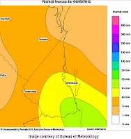
The rainfall forecast images (left) shows falls of between 15-25mm are expected to fall over the Gold Coast region on Tuesday.

Wednesday will see showers and isolated afternoon/evening thunderstorms developing before a trough moving eastwards off the southern Queensland coast overnight.

However Thursday and the remainder of the working week should see clear skies and fine weather with tops around 24-25 degrees.

April 25, 2010

Strong wind warning for Monday's Anzac holiday


Strong 25/30 knot winds with 3m seas from Point Danger to Sandy Cape (excluding Hervey Bay & Moreton Bay) are expected to affect mainly offshore waters from early Monday 26th April 2010, with a Coastal Wind Warning issued at 10:45am on Sunday morning.

April 21, 2010

Rainy weather dampens tourism


With seemingly endless forecasts of 'just a shower or two' for the Gold Coast over the last couple of weeks is leaving tourism operators not only with dampened spirits but lost business and revenue.

Today's showers seemed more like patchy rain with moderate falls occurring during the day across the Gold Coast, especially closer to the coast and near Springbrook in the hinterland.

The top 24hr rainfall figures to 9am today (21st April 2010) recorded 66mm at Southport, 56mm at Moldendinar, 55mm Upper Springbrook, 46mm at Oxenford and 44mm at Loder Creek Dam. (Source: BOM Qld Flood Warning Centre)

According to news articles at the Gold Coast Bulletin, Melbourne has 'stolen' our weather with city recording higher temperatures around 27-29 degrees. With the constant rainy weather here on the coast, bookings for outdoor activities such as river cruises and houseboats are at low levels with tourists preferring the sunny weather. (Source: Gold Coast Bulletin)

It appears Melbourne have also taken our afternoon summer storms with a severe storm lashing the city at around 6pm yesterday, causing flash flooding and roof damage to properties that prompted over 300 calls to the State Emergency Service. (Source: The Age).

The outlook for the Anzac weekend forecasts the showers clearing on Saturday but possibly returning again from Sunday afternoon.

April 13, 2010

Goodbye severe storms, hello East Coast Lows


With the onset of the cooler autumn weather, the chance of severe thunderstorms impacting the Gold Coast and South-East Queensland drops quite low.

However, it doesn't mean that we aren't out of the woods in regards to severe weather activity - the East Coast Low.

April 1, 2010

Easter weather outlook

It's looking like a mostly fine and warm Easter long weekend here on the Gold Coast, the forecast from the Bureau of Meteorology expecting a brief shower or two tomorrow, otherwise it's mostly fine all weekend including Easter Monday at a constant top of 27 degrees.

A new high pressure system will move across the Great Australian Bight over the
next few days and nose into the Tasman Sea on Sunday allowing a firm ridge again
to spread along most of the east coast. At the same time a low over the Tasman Sea will intensify. The combination of the two systems will result in a fresh to S/SE airflow again becoming established along much of the east coast by Sunday.

Mostly fine conditions will persist over southern parts of the state into early next week due to the influence of the ridge, with only isolated showers expected about the exposed coast and ranges. Temperatures across the state will generally be near or below average through the weekend and into early next week due to winds generally coming from the S to SE direction.

Enjoy your weekend and drive safe.

March 23, 2010

Are you prepared for a disaster on the Gold Coast?

As the clean-up continues across the Central Queensland coast from Tropical Cyclone Ului, the flow on effects are causing further problems for residents, businesses and tourists including:
  • thousands of homes & businesses are still without power across the Central Queensland coast (60,000 at the height of the cyclone, 24,000 as of last night),
  • without power for pumping stations yesterday, mains water supply was running short in many areas
  • businesses that are trading are often only accepting cash as EFTPOS facilities are offline for many and customers are running out of cash with limited/no ATM's working or banks open,
  • those without mains power (or generators) are likely to have food spoilage with no refrigeration to keep food fresh or frozen,
  • access to fuel supplies are limited as service stations without power cannot pump fuel.

Putting this into perspective, how prepared would you have been if a cyclone or other disaster affected the Gold Coast right now similarly to Tropical Cyclone Ului?

The Gold Coast City Council's disaster management website (goldcoastcity.com.au/disaster) has excellent resources and information on how to be prepared for a disaster event. As a community, our strongest buffer in any disaster is: be informed, be prepared.

Simple ideas include:


The following basic tips regarding getting prepared are from Council's Disaster Management at Home Guide, which is available for download from their website, or printed copies are available from Council offices and libraries.

There are 3 easy steps to plan for an emergency:
  1. Have an emergency plan -
    • List important details and contact numbers of neighbours, family/friends and emergency response agencies to help your family, household or visitors.
    • If you can't get home or in contact with each other, list a meeting place or a contact to leave a message (e.g. neighbour)

  2. During an emergency -
    • Listen to the radio for information and updates
    • Stay at home unless told otherwise
    • Have emergency plan and emergency kit ready
    • Be prepared to look after yourself and family for up to three days

  3. During an evacuation -
    • Take emergency plan and emergency kit
    • Turn off water, electricity (mains supply) and gas (if applicable)


Emergency Information & Contacts:

If a disaster event or emergency does occur on the Gold Coast, your best source for information and updates will be via your local radio station.

Alternate sources of official information include Gold Coast City Council's disaster management website (goldcoastcity.com.au/disaster) for disaster alerts and media releases (pending power & internet are available), or by telephone through Council's Disaster Hotline on 1800 606 000.


If you do find yourself requiring assistance during a disaster for flood or storm emergencies only, contact the State Emergency Service (SES) on 132 500.


For all other or life threatening emergencies, always call Emergency Triple Zero 000.


Take the time now to read through this information, and get your emergency plan and emergency kit ready. Remember: be informed, be prepared.

Freak storms hit Perth, possible storms forecast for South East

The worst storms, possibly in 50 years, have hit Perth overnight with 120km/h winds and large hail causing widespread damage and blacking out over 150,000 homes and businesses at the height of the onslaught (Source: ABC News).

Additionally, possibly some of the best lightning photo's we've seen for a while where taken by 'stormgirl26' of http://waweathergroup.com (with one of the photo's shown here)

For the south east corner of Queensland, today's forecast predicts a few showers increasing to showers and storms in the afternoon across much of the south-east and southern interior.

Will we see any severe storms here on the coast today? Let us know your thoughts.

March 21, 2010

Central Qld relatively unscathed by Ului, no storm surge for Gold Coast

After crossing the Central Queensland coast overnight, ex-Tropical Cyclone Ului is now just a tropical low making it's way west towards the Northern Territory, leaving up to 60,000 homes without power and causing moderate damage to buildings and the environment.

However, most residents and officials are counting their blessings as the damage was mostly to trees, crops and only a handful of homes with missing roofs, and no reports of major injury or death.

During the night, @Dirriel mentioned via Twitter that they heard on the scanner that police where called to pick-up a pregnant woman about to give birth just before the cyclone arrived!

We have also made our final update to the Satellite Image Animation and uploaded to YouTube for all to see:


Here on the coast, the feared 'storm surge' from Ului's tail that was headline news for local media last week (as reported in our previous blog post) has failed to eventuate, with monitoring stations reporting no abnormal rises in sea/tide levels throughout the last 72 hours.

Looking ahead into the week and mostly fine conditions are expected to dominate with the occasional shower hanging around. The extended Queensland outlook does mention "an upper trough will move across southern parts of the state during Tuesday and will trigger isolated storms about the south-east", however current official forecasts for Tuesday only mentions possible showers.

TC Ului packs a punch with 200km/h winds

Tropical Cyclone Ului has already made 'islandfall' and affecting the Whitsunday Islands, with Hamilton Island recording a 202km/h wind gust at 12:30am. The eye of the cyclone is almost over the island as at 1:04am with wind gusts starting to drop.

The Mackay weather radar image at 1:10am clearly (left) shows the circular eye just passing over the islands and just beginning to make landfall near Proserpine.

Ergon Energy along with local residents & visitors (via Twitter) are reporting power outages across the region including Mackay, Sarina, the Whitsundays and Gladstone

The latest Tropical Cyclone Advice from the BOM "At 1:00 am EST the cyclone is estimated to be 69 kilometres east of Bowen and 125 kilometres north northwest of Mackay.

The cyclone is currently crossing the Whitsunday Islands as a severe tropical cyclone and is expected to move west and make landfall Bowen and Proserpine in the next hour. The cyclone is then expected to weaken as it moves inland later today."


Meanwhile here on the Gold Coast, it's a relatively calm night compared to up north, with the Gold Coast Seaway recording winds at 30km/h gusting up to 35km/h at 1:00am.

It will be a sleepless night for our friends in Central Queensland, stay safe and remember to not venture outside if you find yourself in the eye of the cyclone as winds may remain light for up to an hour - very destructive winds from a different direction could resume at any time.

March 20, 2010

TC Ului re-intensifies to Category 3, expected to cross early Sun morn


Central Queensland communities between Cardwell and Yeppoon are bracing for Tropical Cyclone Ului's arrival early Sunday morning between midnight to 2am around Proserpine, Arlie Beach and Shute Harbour.

A very committed Twitterer '@qldwhitsundays' are keeping their followers up to date with regular Tweets and live webcams via http://www.whitsundaysonline.net/webcams. They are also prepared with backup wireless internet connections, generator, food and water - our best and safest wishes to them and everyone in the path of the cyclone.

We've updated the Ului Satellite Imagery animation up to 7:30pm, and can be viewed below:


The latest Tropical Cyclone Advice from the Bureau of Meteorology has the following advice:

At 7:00 pm EST Severe Tropical Cyclone Ului, Category 3 was estimated to be 190 kilometres northeast of Mackay and 405 kilometres east southeast of Townsville and moving west southwest at 31 kilometres per hour.

The cyclone is expected to cross the coast between Ayr and Mackay, most likely in the Proserpine region as a severe tropical cyclone early Sunday. The cyclone is then expected to weaken inland later on Sunday.

VERY DESTRUCTIVE wind gusts to 200 km/hr near the cyclone centre may affect coastal and island communities in the threatened area late tonight and early Sunday.

Meanwhile here on the Gold Coast, dangerous surf conditions that claimed the life of a young lifesaver yesterday, are expected to ease with the latest Severe Weather Warning no longer including areas south of Cape Moreton.

March 19, 2010

Lifesaving competitor dies at Kurrawa, rough conditions blamed

Rough surf conditions at the Australian Surf Life Saving Championships on Kurrawa beach have claimed the life of 19-year-old NSW competitor Saxon Bird (Source: Surf Live Saving Qld). According to news reports, it's believed the surfer was knocked unconscious by his own surf ski, which washed up on the beach at approx 11:30am.

This prompted an air and sea search of the area, to which Bird was found less than an hour later by a fellow life saver. Paramedics performed CPR on the young surfer until he arrived at Gold Coast Hospital in a critical condition, but later passed away. (Source: Seven News)

The competition has been suspended, with police investigating as to why the competition went ahead despite the dangerous surf conditions. Officials from the competition had deemed the conditions safe to proceed today, despite a Severe Weather Warning being issued last night expecting dangerous surf conditions to develop today.

Meanwhile, preparations are continuing along the central Queensland Coast with the small sugar town of Proserpine expected to be in the direct path of Tropical Cyclone Ului. The cyclone was downgraded to a Category 2, with the visual satellite images showing the system losing it's eye and appearing to be dissipating. An animation of the Satellite Images over the last 3 days shows the system moving south.


At this stage, no further official warnings from the Bureau have been issued regarding any potential 'storm surge' or other adverse conditions to affect the Gold Coast over the weekend.

March 18, 2010

Storm surge fears & dangerous surf for Gold Coast

Severe Tropical Cyclone Ului is expected to move southwest towards the central Queensland coast on Friday and over the weekend, resulting in a cyclone advice being issued for areas between Cardwell and Yeppoon by the Bureau.

Guests and staff have already been evacuated from resort islands Heron and Lady Elliot with Coral Point Lodge, Shute Harbour, expected to vacate.

As at 4pm, Category 3 'Ului' was located over the Coral Sea about 1100km northeast of Mackay, while a large high was located over the Tasman Sea and will remain near stationary.

The windy conditions over much of the Queensland east coastal waters will continue due to the tight pressure gradient generated by a combination of a high pressure system situated in the Tasman Sea and Severe Tropical Cyclone Ului. Seas and swell are expected to increase along much of the Queensland east coast and produce dangerous surf conditions on the exposed coasts.

So whilst the cyclone may not be directly headed for us, it's effects will still be felt here on the coast, with the Bureau of Meteorology issuing a Severe Weather Warning at 5pm that includes the South East Coast district for dangerous surf conditions. The warning indicates some beach erosion is expected to develop about exposed beaches during Friday, particularly about the Sunshine and Fraser coasts. With this in mind, it might be best to avoid the beaches tomorrow and over the weekend.

The Gold Coast Bulletin today warned readers of a potential storm surge and threat of 8m waves to affect the Gold Coast as a result of the region being lashed by the tail end of Cyclone Ului. Quotes within the article from the Weather Channel's meteorologist Dick Whitaker include:

"For the Gold Coast the biggest effect is ocean swell, with booming seas, coastal erosion issues and very large waves which could be ... seven to eight metres"

"The storm surge is more like a tide, so with waves on top of that, the freak tidal effect pushes water further inland than normal."

"The Gold Coast will probably see at least a slight storm surge." (Source: Gold Coast Bulletin)

However, as the path and effects of the cyclone remain uncertain, the current marine/boating forecast from the Bureau of Meteorology for our region indicates:

Friday: Winds SE 20/25 knots ... Waves breaking dangerously close inshore, particularly about Bars. Seas 2 to 3 metres. Swell: E/NE 2.5 to 3.5 metres ...

Saturday: Winds E/SE 20/30 knots ... dependent on the movement of Tropical Cyclone. Large E/NE swells, breaking dangerously inshore.

Sunday: Winds SE/NE 20/30 knots, easing to 15/20 knots late in the day (Source: BOM)

Regardless of what happens, Gold Coast City Council's disaster management committee and local SES volunteers are on standby (Source: Gold Coast Bulletin). Full information on how to be prepared for a disaster event on the Gold Coast can be found on Council's website.

March 16, 2010

Tropical cyclone path remains 'Ului'-sive, but wild weather to return

The expected path of Tropical Cyclone Ului remains elusive with differing models and forecasts on whether the Category 5 storm will reach the Queensland Coast.

The official forecast track map (first image, left) and bulletin's from the Bureau earlier in the week indicated the cyclone would likely not reach the Queensland coast and remain out to sea.


However, forecast models (second image, left) by the United States Navy Joint Tsunami Warning Center has 'Ului' heading westwards towards the coast on Friday, however it would weaken before making landfall between Rockhampton and Mackay on Sunday morning. By the time it reaches the coast, winds are likely to have dropped to about 60 knots (111 km/h)

A Courier Mail news story today highlights the US Navy model, whereby forecaster Geoff Doueal said it was common for models to disagree. "There's not much (weather conditions) steering this at the moment, so it's a wait and see," he said (Source: Courier Mail)

Regardless of the models, the effect of the cyclone is expected to be felt during the next week, with wild weather conditions expected to lash the coasts. As a precaution, the State Government has ordered shark nets and hook lines to be removed from Gold Coast beaches.

As a result, beach goers are warned to only swim at patrolled beaches, not only because the shark nets are no longer in place, but that dangerous surf conditions with seas of up to 7 metres are expected on Friday (Source: ABC News)

At time of posting there are no direct weather warnings for the Gold Coast region, however there is currently a Coastal Wind Warning that extends down to Double Island Point, which will likely be expanded to include Point Danger as the week progresses.

What are your thoughts? Leave a comment of what you think will happen.

March 13, 2010

Will Qld see it's last cyclone for the season?


According to the Bureau of Meteorology's Tropical Cyclone Outlook, a developing tropical low is located near Vanuatu and is expected to intensify further and become a tropical cyclone within 12 to 24 hours. This system is expected to move slowly westward (i.e. towards Australia) during the weekend.

The current Mean Sea Level Pressure Analysis map from the BOM show the cyclone called 'Ului' heading in a north-westerly direction. However, the current synoptic maps at Weatherzone show the cyclone called 'Paul' approaching the Central Queensland coast towards the end of next week.

Our friends at queenslandonline.net have been Twittering (@qldonline) information from the weather models (including the US Navy) that the cyclone would cross land on Friday evening or Saturday morning between Mackay and the Whitsundays with wind speeds over 125km/h.

Anyway, from the looks if it the South East corner won't be directly impacted, however it looks like further showers and windy conditions to continue on the Gold Coast.

March 7, 2010

Will autumn storms pack any punch in 2010?

The summer storm season has passed us again for another year, with relatively few storms affecting the Gold Coast this time compared to previous years (in my opinion at least). Normally, the onset of colder weather spells the end of afternoon thunderstorms that generally come hand in hand with a hot day.

However, after a spate of severe thunderstorms affecting Melbourne again today, yesterday's deluge dropped hail up to 10cm in size and heavy rain causing flash flooding. Around 100,000 homes lost power and major public facilities damaged including Docklands Stadium, the Arts Centre and Southern Cross Railway Station (Source: ABC News).

This video posted on You Tube just goes to show how seeming 'calm' can become havoc so quickly.


Our first set of autumn storms are predicted to arrive on Wednesday afternoon, with the following outlook from the Bureau of Meteorology State Outlook:

On Wednesday the high in the Great Australian Bight becomes well established and intensifies to a central pressure of about 1037 hPa. This high pushes a vigorous S/SE change up the New South Wales coast reaching SE Queensland during the day. This change is expected to kick off afternoon showers and thunderstorms over parts of SE Queensland.

So, do you think we could still be in for a pounding from storms during autumn, or will we not see any really severe storms until spring/summer returns again? Leave us a comment with your local knowledge or experiences.

March 2, 2010

Gold Coast gets drenched, but not as wet as some!

Areas of the northern Gold Coast received over 150mm of rain over the past 24hours, but the worst of the weather stayed north around the Sunshine Coast and Wide Bay areas.

In the 24hrs up to 9am this morning (2nd March), Coomera recorded 161mm, 147mm at Evandale (Bundall) and 136mm at Southport.

This afternoon at 4:20pm, the Bureau of Meteorology downgraded the Severe Weather Warning as heavy falls are no longer expected causing flash flooding.

However further light to moderate falls are still expected tonight, with a general Flood Warning for Coastal Streams/Rivers still current warning of rapid rises in areas of heavy rainfall.

Additionally, the Gold Coast has been spared damaging wind gusts of up to 100km/h staying north of Cape Moreton and out west in the Granite Belt and Darling Downs. The highest gust recorded at the Gold Coast Seaway was 61km/h at 5am and 1pm today.

There is still a Coastal Wind Warning current warning of strong 25/33 knot E/SE winds between Cape Moreton to Point Danger, including Moreton Bay. Seas to 3 metres in open waters with a developing 2 to 2.5 metre S/SE swell. Seas rising to 1.6 metres in Moreton Bay.

What was your experience? Leave a comment or follow us on Twitter @weathergc

March 1, 2010

Severe Weather & Coastal Wind warnings for SEQ

It's beginning to look like the south-east corner is going to get a pounding, with the Bureau of Meteorology issuing a second Severe Weather Warning at 4:35pm specifically for the South-East coast district and Wide Bay Burnett districts for flash flooding and damaging winds tonight and tomorrow.

New auto-alerts of QLD Weather Warnings via Twitter

Overnight we have implemented a feature automatically post to Twitter any new updates for Quensland Weather Warnings from the Weatherzone RSS Feed using twitterfeed. Any of these automatic posts will be prefixed by 'Auto-Alert:'.

At this stage, all updates will be for any warnings for the whole of Queensland, however we are testing filtering options to only broadcast updates relating to the South-East coast forecast districts.

Don't worry, we will still be posting detailed Twitter posts for any warnings that impact the Gold Coast.

Let us know your thoughts and ideas, do you want to see the auto-alerts for all Queensland warnings, or just the Gold Coast/South East region?

February 28, 2010

Monsoon low edges closer to the South East Qld

A monsoon low that has been causing heavy rain and localised flooding over the Northern Territory is making it's way into Queensland and heading for the south-east corner.

The Bureau of Meteorology issued a Severe Weather Warning yesterday for the Channel Country (south-western Qld including Birdsville) for flash flooding.

Updated: Tsunami threat eases, Gold Coast beaches remain closed

UPDATE: The BOM has issued a cancellation of the tsunami warning for Queensland at 4:11pm. The main tsunami waves have passed, but small unusual waves, currents & abnormal tides may exist for hours or even days. Emergency Management Queensland will advise when it's safe to return to coastal areas.

ORIGINAL: POST: The latest Tsunami bulletin from the JATWC & BOM at 3:11pm still warns of potential dangerous waves and strong ocean currents, however foreshore inundation is no longer expected with the 'assistance' of an outgoing tide.

Gold Coast beaches are to remain closed for the remainder of today (Sunday 28th February).

February 27, 2010

Chile Earthquake prompts tsunami bulletin for QLD

An 8.8 magnitude earthquake off the coast of Chile, South America has prompted the Joint Australian Tsunami Warning Centre to issue a Tsunami Bulletin for Queensland and New South Wales as well as Norfolk and Lord Howe Islands

Rain on the way for the South East

According to Bureau of Meteorology computer generated forecast rainfall maps, it looks like it's going to get wetter in the South-East corner from now until Tuesday.

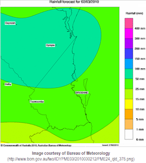
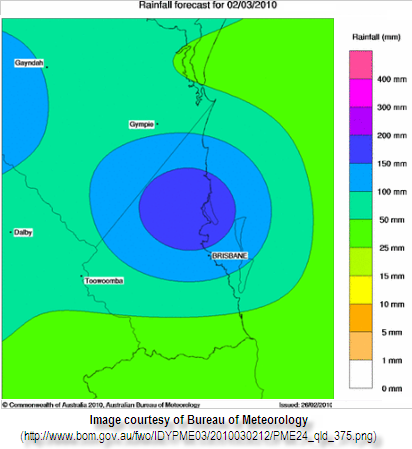
The rainfall forecast maps show an expected 10-15mm falling in the Gold Coast area on Sunday, 15-25mm on Monday, and between 25-50mm in the south and 50-100mm in the northern areas of the Gold Coast.

February 16, 2010

More storms, cars swim in Brisbane!

The Severe Thunderstorm Warning was issued early today before midday for heavy falls and flash flooding, coming in diagonally from the north-west with some moderate-heavy falls.

February 15, 2010

Gold Coast Thunderstorms 15th Feb 2010

Thunderstorms rolled into the Gold Coast area today at around 8-9pm, however most of the intensity was spent over the Fassifern Valley area and the Brisbane bayside.


February 14, 2010

Welcome to weathergc.com!

Thanks for visiting weathergc.com, your window to Gold Coast weather!

Our main aim since February 2010 is to provide a place for the residents and visitors to the Gold Coast to share their experiences and knowledge about how the weather is affecting their neck of the woods. We'll also share information and the best links from other official sources including weather forecasts and warnings, observations, satellite & radar imagery , power outages and road/transport closures, etc.

Often when severe weather events occur on the Gold Coast, it can be hours or days before the full extent of what's happened, in what area, to which people. We hope that through our blog (at http://www.weathergc.com), our Twitter updates (via @weathergc) and via our Facebook page (http://facebook.com/weathergc), that everyone can share their personal experiences, local observations as well as photos and videos.

So if it's raining cats and dogs at your place, the couch is floating out the door, or you can't find the candles (but you have your mobile with a Twitter or Facebook account!), we want to know about it! Post a picture, leave a comment, or a Tweet!

Please note that any information posted/tweeted are opinions based on personal experiences and information passed on from other sources for entertainment purposes only. This information may not be accurate, and should not be relied upon as the single point of truth. It is recommended that you refer directly to the official sources of information, forecasts and warnings, etc (i.e. from the Bureau of Meteorology, SES, Energex, etc) to make an informed decision.

Thanks for reading, we look forward to your input and participation!