A monsoon low that has been causing heavy rain and localised flooding over the Northern Territory is making it's way into Queensland and heading for the south-east corner.
The Bureau of Meteorology issued a Severe Weather Warning yesterday for the Channel Country (south-western Qld including Birdsville) for flash flooding.
Today's update has extended the area to this area expanded to include Maranoa and Warrego, southern Central West, southern Central Highlands and Coalfields and western Darling Downs forecast districts.
The warning states "heavy rain is expected to cause localised flash flooding over parts of the Channel Country tonight, extending east into the Maranoa and Warrego, southern Central West, southern Central Highlands and Coalfields and western Darling Downs forecast districts during Monday. These conditions are expected to extend eastwards into southeastern Queensland on Tuesday."
In addition to this, Weatherzone is predicting "Southeast Queensland will see the rain pick up with heavy amounts expected into the beginning of the weak, peaking on Tuesday. Brisbane could see over 100mm through the next few days. One of the areas expected to see the heaviest rain is the Sunshine Coast, which could see as much as 200mm over the next few days."
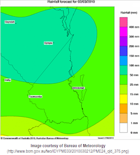
The BOM computer generated rainfall forecast maps has shown a reduction in the amount of rain expected to fall across the Gold Coast area, with approx 25-50mm tomorrow (Monday) and 50-100mm on Tuesday.
Categories
- home
- about us
- blog topics
- about us
- beaches
- cold
- cyclone
- did you know
- disaster management
- east coast lows
- end of the world
- fire
- floods
- forecast
- frost
- heatwave
- holidays
- La Niña
- news
- rain
- road closures
- sandbags
- satire
- school closures
- sea and surf
- SES
- severe weather
- storm surge
- storms
- tides
- tornadoes
- tsunami
- weather
- winds
- winter
- weather station
- community pulse
- links and resources
February 28, 2010
Monsoon low edges closer to the South East Qld
Sunday, February 28, 2010
Tags:
floods,
rain,
severe weather
Copyright © 2010-2011 | weathergc.com |
Login


